")

")
")

")


Around 3:40 pm, 09 October, we start leaving Xinduqiao Town (新都桥镇). Mr.Chen fires up his engine and rolls his white beast and again picks up the National Highway G318 and drives west for our tonight’s destination – Yajiang County (雅江县).
Xinduqiao to Yajiang Road Trip
We choose to continue driving for extra 72km from Xinduqiao Town (Xinduqiaozhen on google map) to Yajiang partly due to the Yajiang’s relatively low altitude of 2500 meters against Xinduqiao’s altitude of 3450 meters; partly due to the fact today’s extra 72km drive will reduce the intensity of our tomorrow’s driving trip.
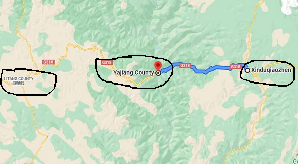
Yajiang’s low altitude gains its reputation of being a nice stop between Kangding (or Xinduqiao ) and Litang (理塘) for G318 travelers including self-drive travelers, bicyclists, or hikers.
Yajiang is a modern town within the traditional Kham Region of the eastern Tibet, now under the administation of Ganzi Tibetan Autonomous Prefecture. Its splendid history brings people back to its prime days as the important stopover and ferry point for the ancient Tea and House Route.
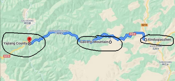
Driving over Gaoersi Mountain Pass at 4412 m
Now we are on the way from Xinduqiao to Yajiang. The driving map tells we have to get over a high pass known as Gaoersi Mountain Pass at 4412 meters sea level (高尔寺山海拔4412). Overcast and it is getting darker on the road up to the Gaoersi Mountain Pass. It starts snowing on the higher mountain road due to the changeable weather and cool temperatures at high altitudes.
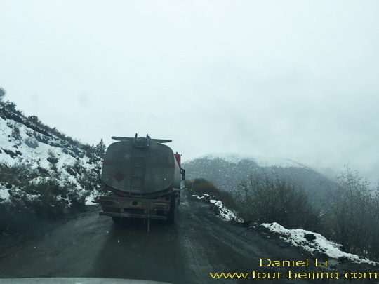
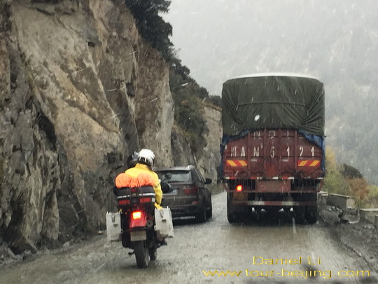
What makes things worse is the unrestored and unrenovated mountain road before and after the Gaoersi Mountain Pass and the terrible road turns out to be as long as 24 km! Actually you cannot call it “Highway” since it is very bumpy, muddy, messy and some sections of the horrible road don’t have any guard rails to provent vehicles from straying into the deep gorges.
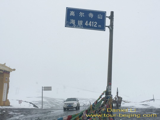
At 4:30 pm, we reach the Gaoersi Mountain Pass and see a signboard standing on the top with the words “Gaoersi Mountain Pass 4412 meters Altitude” in Chinese. We stop and stay there just for a few minutes, taking a photo of the signboard as a rememory and pay repect to the simple Gaoer Temple nearby with our eyes.
Driving over Gaoersi Mountain Pass, we find it is snowing heavily, making it even more difficult to drive along the muddy and bumpy road. We have to carefully steer clear of passing-by trucks, cars and even motorcyclists.
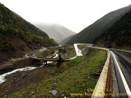
Eventually the highway condition is getting much better, and back to the normal level of a standard highway, wide and with guard rails. The road descends fast from the over 4000-meter-altitude Gaoersi Pass to a little over 2500-meter Yajiang.
Arriving at Yajiang County
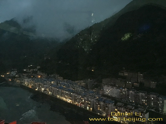
At 6:00pm, we arrive at the downtown of Yajiang County. It is a modern town set in the deep valley of Yalong River (雅砻江) which gives rise to the name of Yajiang. It is a 1,323 km long river, a tributary of the Yangtze River. Its source is on the Tibet-Qinghai Plateau in southeast Qinghai.
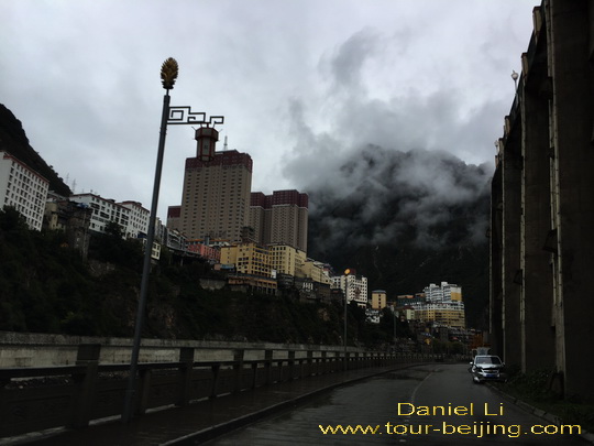
The town looks very much compact with crowded buildings cascading from the two sides of the river valley. It is a drab and dusty city but with some modern tall buildings standing here and there. There are also a few old side streets that betray an old town. Crowded buildings flank Yalong River cutting the town into two parts.
It doesn’t take much efforts to secure two rooms at a nice hotel in Yajiang. But we do suggest you’d better reserve your hotel in Yajiang during the tourist peak season.
Any questions on the drive from Xinduqiao to Yajiang, just drop a line.
Add-On
Drive from Hanzhong to Ya’an
Ya’an Night View
Most Beautiful Sky Road in China
Moxi Old Town ( Tips, Photos & Map)
Hailuogou Glacier Camp No.04 (Tips,Photos & Map)
Hailuogou Glacier Camp No.03 (Tips, Photos & Map)
Kangding (Tips, Photos & Map)
Drive from Kangding to Xinduqiao
Drive from Xinduqiao to Danba
Jiarong Tibetan Blockhouses
Jiarong Tibetan Ancient Watchtowers
Drive from Xinduqiao to Yajiang
Drive from Yajiang to Litang
Drive from Litang to Daocheng
Drive from Litang to Batang
Drive from Batang to Mangkang
Drive from Shangri-la to Daocheng
Drive from Daocheng to Yading
Yading Brings You Inner Peace
Hassle-free Chengdu & Sichuan Guided Tours
If you don’t want to go the do-it-yourself route and prefer the hassle-free escorted tours, here are some options for Chengdu and Sichuan guided tours:
Chengdu tour
Chengdu Car Rental with Driver
Create My Chengdu Trip
Jiuzhaigou Tour
Sichuan Tour
Further Readings
Top 10 Attractions in Chengdu
Best Time to Visit Chengdu
Chengdu Airport
Railway stations in Chengdu
Chengdu Taxi
Chengdu Research Base of Giant Panda Breeding (Tips, Photos & Map)
How to visit Wuhou Shrine
How to visit Du Fu Thatched Cottage
How to visit Jinsha Site Museum
How to visit the tomb of Wang Jian in Chengdu
How to Visit Wangjiang Pavilion Park in Chengdu
How to visit Qingyang Palace in Chengdu (Tips, Photos & Map)
How to Visit Jinli Street
How to visit Kuan Alley and Zhai Alley
Qintai Road, Qintai Gujing Chengdu (Tips, Photos & Map)
Shaoling Road Bar Street Chengdu (Tips, Photos & Map)
Jiuyanqiao Bar Street in Chengdu (Tips, Photos & Map)
The Old Teahouse in Pengzhen Town, Chengdu
Bipenggou is a fairyland in Autumn
When is the best time to visit Jiuzhaigou?
Best Places to Visit Autumn Leaves in Sichuan
Top 10 Places to Visit in Sichuan
Ruoergai Grassland, my first trip to Ruoergai Grassland