")

")
")

")
ABC of Mangkang
Around 3:45 pm after a brief break at the filling station in Xiaqionzhen in BatangCounty (巴塘), we again start up our trip along G318 west for our next destination – Mangkang (芒康 ) in Tibet. Mangkang is also known as Markham or Karkam in Tibet, a county under the administration of Qamdo City (昌都) in the Tibet Autonomous Region.
Mangkang is located amid the border areas of the three provinces including Sichuan, Tibet and Yunnan. It is adjacent to Batang County in Sichuan on the east and Deqin County in Yunnan on the south. Both the National Highway G318 and G214 run through Mangkang County. It is an important stepping stone to enter the three connected provinces.
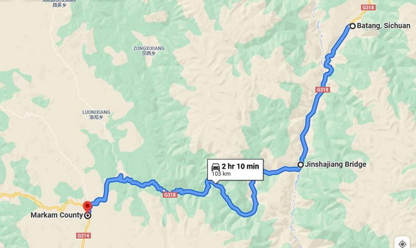
Batang to Mangkang Road Trip
It is a 110 km drive from Batang to Mangkang (Karkam). The first 35km drive is easy and uneventful when we pass through Zhubalong Township ( 竹巴龙乡) which is the west tip of Batang County along G318.
The Zhubalongxian (珠巴龙乡) in Batang abuts Zhubalongxian (朱巴龙乡), the east tip of Mangkang (Karkam). The two townships have the same Chinese pinyin ( romanization of Chinese), but with different Chinese characters.
Jinshajiang Bridge (Jinsha River Bridge)
Passing through Zhubalongxiang Township in Batang, we soon go across Jinshajiang River Bridge (金沙江大桥) which divides the two townships – Zhubalongxiang Township ( 竹巴龙乡) in Batang and Zhubalongxiang Township (朱巴龙乡) in Mangkang (Karkam).
Jinshanjiang River (金沙江) is largely the dividing borderline between Sichuan and Tibet. We stop at the middle of Jinsha River Bridge, straddling the the two provinces ( Sichuan and Tibet ) while snapping a photo of the borderline sign attached to the bridge cememt handrail.
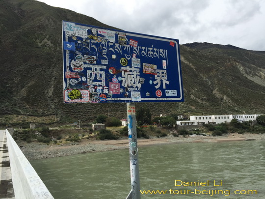
Driving across Jinsha River Bridge (金沙江大桥), we run into the area of Zhubalongxiang Township (朱巴龙乡) in Mangkang (Karkam), Tibet. Soon we have to stop at the security checkpoint set up by the local Zhubalongxiang Public Security Bureau.
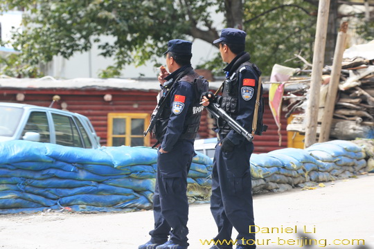
The security checkpoint at Zhubalongxiang
Mr.Chen and I leave our vehicle in the waiting line and go out to the roadside office windows, taking all the personal travel documents with us – ID card, or passport and driving licences and the vehicle certificate. We see policemen with their weapon resting lazily slung over their shoulders.
At the checkpoint, we are offered a speed limit ticket which requests us to drive within two hours to cover the 71 km distance ahead between Zhubalongxiang Township and the downtown of Mangkang. So we have to limit our drive within 2 hours before we get to Mangkang, just 75km away.
We much keep the ticket till the policemen at the checkpoint in Mangkang collect and check it. Why two hours for the 75 km? So slow, like a slow moving snail. The ticket says the road ahead is full of risks with possible falling stones and the fact that some sections are in the state of disrepair.
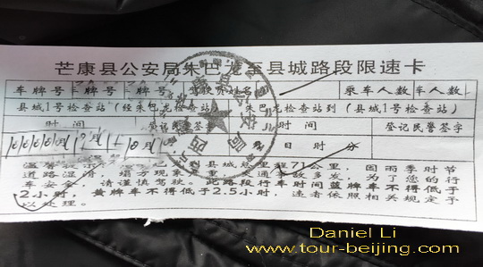
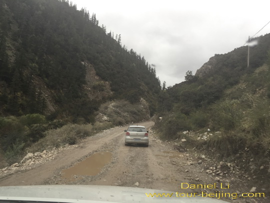
The 71-km G318 Highway from Zhubalong Township to the downtown of Mangkang has complicated geographical conditions. The road is often collapsed in rainy season. The roadside river sometimes encroaches the road. In some areas, the road sinks, bumpy and muddy.
The most dangerous thing is the falling stones, blocking the road with a potential risk of harming the people on the way. On route, for several times we have to stop and clear the fallen stones on the road ahead. Sometimes we have to gingerly drive along the cliff swept with the scree.
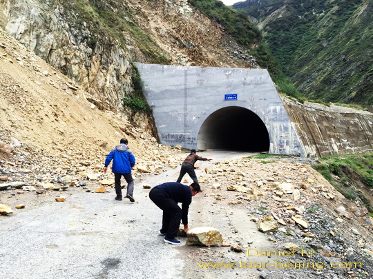
The road clings to the sheer cliffs, often with turns and curves, and we have to drive slowly and carefully to avoid colliding with coming vehicles.
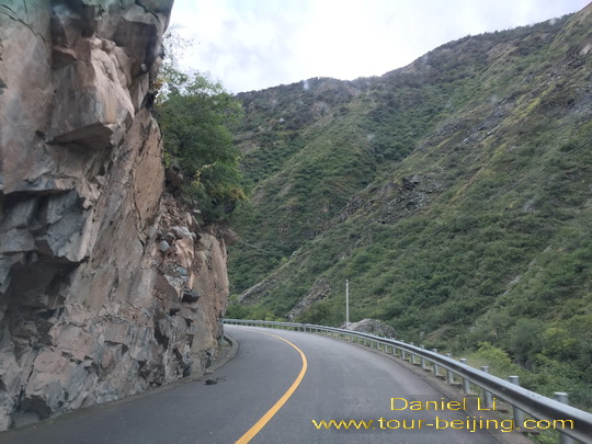
Some sections of the highway are just in a state of disrepair, muddy, rutted and without any handrails.
Two hours late, around 5:50 pm, we get to the No.01 Checkpoint in the downtown of Mangkang (Karkam). We again have to stop and have our personal ID cards checked and then continue our trip, and this time we get off the National Highway G318 and turn south and drive along the National Highway G214.
The sun is setting and we have to hurry up to catch the time lost on the speed limit road just passed.
Any questions on the drive from Batang to Mangkang, just drop a line.
Add-on
Drive from Hanzhong to Ya’an
Ya’an Night View
Most Beautiful Sky Road in China
Moxi Old Town ( Tips, Photos & Map)
Hailuogou Glacier Camp No.04 (Tips,Photos & Map)
Hailuogou Glacier Camp No.03 (Tips, Photos & Map)
Kangding (Tips, Photos & Map)
Drive from Kangding to Xinduqiao
Drive from Xinduqiao to Danba
Jiarong Tibetan Blockhouses
Jiarong Tibetan Ancient Watchtowers
Drive from Xinduqiao to Yajiang
Drive from Yajiang to Litang
Drive from Litang to Daocheng
Drive from Litang to Batang
Drive from Batang to Mangkang
Drive from Mangkang to Deqin
Kawagarbo Viewed from Feilaisi
Drive from Deqin to Shangri-la (Zhongdian)
Ganden Sumtseling Monastery Dwells Your Soul
Pudacuo is an earthly paradise
Drive from Shangri-la to Daocheng
Drive from Daocheng to Yading
Yading Brings You Inner Peace
Hassle-free Chengdu Guided Tours
If you don’t want to go the do-it-yourself route and prefer the hassle-free escorted tours, here are some options for Chengdu and Sichuan guided tours:
Chengdu tour
Chengdu Car Rental with Driver
Create My Chengdu Trip
Jiuzhaigou Tour
Sichuan Tour
Further Readings
Top 10 Attractions in Chengdu
Best Time to Visit Chengdu
Chengdu Airport
Railway stations in Chengdu
Chengdu Taxi
How to visit Wuhou Shrine
How to visit Du Fu Thatched Cottage
How to visit Jinsha Site Museum
How to Visit Tomb of Wangjian
How to Visit Wangjiang Tower Park
How to Visit Qingyang Taoist Temple
How to Visit Jinli Street
How to visit Kuan Alley and Zhai Alley
How to visit Qintai Road, Qintai Street Chengdu
How to visit Shaoling Road Bar Street
How to Visit Jiuyanqiao Bar Street
The Old Teahouse in Pengzhen Town, Chengdu
Bipenggou is a fairyland in Autumn
When is the best time to visit Jiuzhaigou?
Best Places to Visit Autumn Leaves in Sichuan
Top 10 Places to Visit in Sichuan
Ruoergai Grassland, my first trip to Ruoergai Grassland
Hello Daniel
Are foreigners allowed to enter Mangkang without a Tibet permit?
Thanks
Hi Ameen,
Sorry for my much belated reply! Basically you need a Tibet permit to visit Mangkang.