")

")
")

")
Last night (October 15), it was dark and raining outside, I habitually took out my laptop. The owner at the temple-turned inn said his place had wifi service. It showed that I was connected to the wifi, but I couldn’t access the internet. A bit frustrated, I had to experience a night without internet, the first internet-less night for the past 10 days since we started our self-drive trip from Zhengzhou on October 06.
Sleeping alone in a rickety makeshift room inside a Buddhist hall, I felt solitude came back to me. The good thing about solitude is that it gives you time and space to think. Yes, great things come out of solitude, or out of a weird place like this temple-turned inn.
I fell into a deep thought about Shangri-la. Where was Shangri-la? Was Yading a real and last Shangri-la? In his novel “Lost Horizon” published in 1933, the British novelist – James Hilton ( 1900 – 1954 ) was vague about the real place of his Shangri-La. Was Zhongdian ( now going so far as to have been rechristened as Shangri-la”) ? Or Deqin ( Kawagebo, ) ? Or here in Yading? Yading is part of Riwa Town which has been also renamed as Shangril-la Town.
There are multiple places in China that show many similarities to the fictional Shangri-La – the lamasery, high mountains, inner peace, and long life. Maybe the real Shangri-la only exists in James Hilton’s head.
Then another person came to my mind, Joseph Rock (1884 – 1962), an Austrian-American explorer and botanist. It was said James Hilton’s novel “Lost Horizon” was based on the articles written by Joseph Rock published in the National Geographic magazine in the United States.
Sponsored by the National Geographic, Joseph Rock spent 27 years in China from 1920s to 1940s, making plant collecting expedition across many areas of Yunnan and Sichuan provinces.
In June, 1928, arranged by the King of Muli, Joseph Rock and his team made an expedition to Daocheng and Yading. Later he wrote:
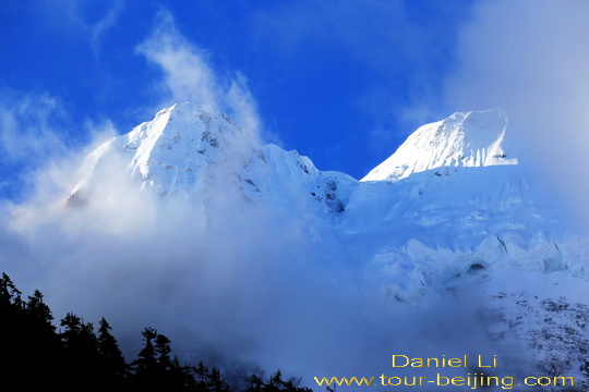
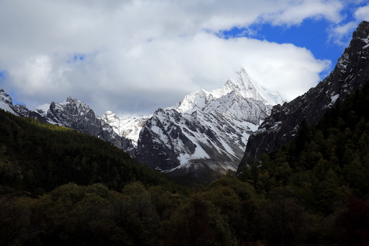
“In a cloudless sky before me rose the peerless pyramid of Mt.Jambeyang (央迈勇), the finest mountain my eyes ever beheld. The sky was greenish black. The snowy pyramid was grey, but the apexes of both it and Mt.Chenrezig (仙乃日) suddenly turned a golden yellow as the sunrise kissed them.”
So was Yading the real Shangri-la? With the deep thinking uninterrupted by the wireless night, I was in a trance, as if I had lived in a bucolic village with glacier-fed lakes, limpid brooks and expansive meadows, encircled by the three sacred snow-capped mountains – a holy trinity of Mt.Chenrezig (仙乃日6032m), Mt.Jambeyang (央迈勇5959m) and Mt.Chana Dorje (夏洛多吉5958m).
Of course, in this earthly paradise, you don’t have to wear an anti-pollution mask against smog (wumai”雾霾). I fell into sound sleep hoping for a rainless and snowless day the next day.
Early this morning I’m woken up by rapid knocks on my door by Mr. Chen. Last night he and his wife just slept in the room opposite mine. He doesn’t even wait for me to get up and open the door, he shouts outside: “it is going to be a fine day today and last night I saw a stary sky!”. Mr.Chen is a very positive man, but the weather in the alpine area is always changeable, you know.
Electric Cart Ride from Entrance to Luorong Pasture (洛绒牛场)
After simple breakfast, taking our personal backpacks, we go down to the roadside shuttle bus stop at Longtong Ba at the elevation of 3700m. Luckily, soon a bus comes with only three seats available, and we get on the bus as a travel group of three.
The official entrance to Yading Nature Reserve is located near Chonggu Si at the sea-level of 3900m, about 4km from Longtong Ba; 7km from Yading Village (Long Long Ba) and 41km from Tourist Service Center in Shangri-la Town.
Timetable for the shuttle bus service ( April-October ):
Itinerary: Shangri-la Town Tourist Center – Long Long Ba (Yading Village) – Longtong Ba – Zhaguanbeng Station
First Bus: 7:20 and last bus: 5:40pm
Itinerary: Zhaguanbeng Station – Longtong Ba – Long Long Ba (Yading Village) – Shangri-la Town Tourist Center
First Bus: 9:00 and last bus: 7:30pm
Note: Single ride: one and half hours
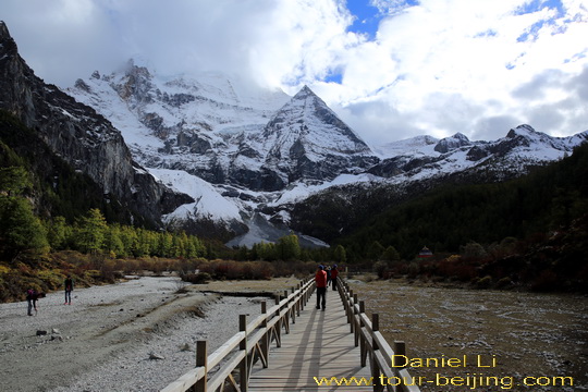
Getting off at the last station of Zhaguanbeng Station (扎灌崩车站 ), we still need to walk up on a steep hillside road for about 500 m to get to the entrance (aka Zhonggu Si Service Center). On the way, we have to move slowly and watch our steps since the views are marvelous surrounding us. Nothing short of stunning and wonder.
Mt.Chenrezig looks bluish and white covered with snow with its apex lit by morning sunlights. Mt.Chenrezig is highest of the three sacred mountains and it represents Goddess of Mercy.
Locals have worshiped the mountains for over 800 years. The 35 kora ( holy hike ) around the highest peak – Chenrezig is much sought after by the local Tibetans.
Basically, we have two choices to go from the entrance to Luorong Grassland (6.7km) – by electric cart (half hour) or hike ( 3-4 hour ). We opt for a golf car return ride to Luorong Grassland ( Single: 50 yuan and return: 80 yuan). Free seating, filled up and go.
The electric cart runs very fast along the paved mountain road ascending higher and higher. Still in the morning with sunshine covered by clouds and high mountains, we feel bitterly cold on the moving golf car. Fortunately I wear a down jacket and a pair of heavy hiking shoes.
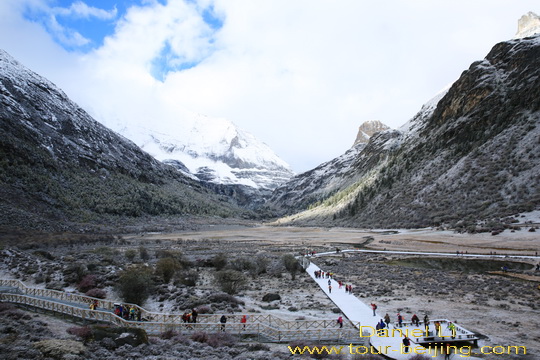
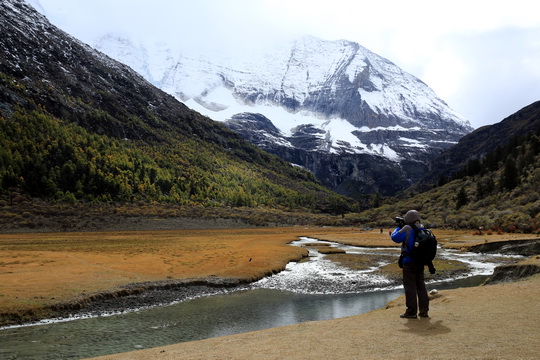
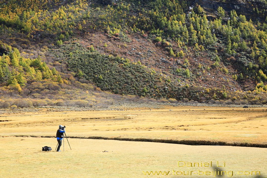
The multi-colored alpine mountains and forests look much pale due to the white frost and leftover snow, making Luorong Pasture less impressive for sightseeing and photography. Luorong Grassland is nestled on a high and flat valley at the foot of Mt.Jambeyang (央迈勇5959m) with expansive meadows. The crystal clear Gongga River winds past the grassland.
Mr.Chen suggest we should not stay long on the otherwise beautiful Luorong Grassland and continue to hike up to Milk Lake (Niunai Lake ). Then return to Luorong Grassland when hopefully it will be sunny and frost and snow will melt away, unveiling the autumn hues of the natural world.
Slog up from Luorong Pasture (4180m) to Milk Lake (4600m) 洛绒牛场 – 牛奶海
( 10 km return: 5-6 hour by hike or 3 hour by horse or mule)
Unable to hire a horse or mule (300 yuan for a return trip) at the rental service of Luorong Pasture, we begin to walk up along the mountain road step by step and get to Milk Lake, a 10-km return trip ( about 5 hours ).
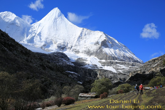
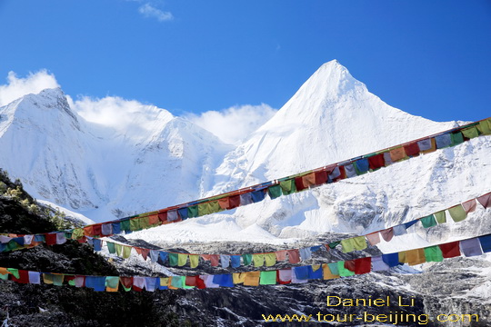
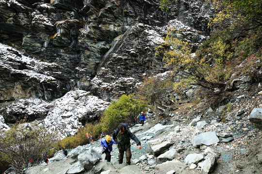
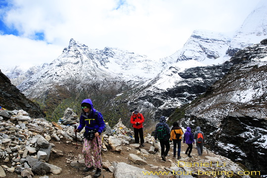
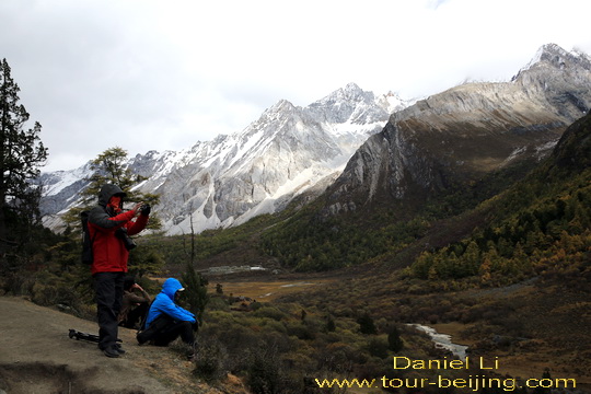
The hiking trail is not paved with smooth stones, instead uncut rocks for most areas, making hiking more strenuous. The rugged snow-capped Mt.Jambeyang looms above us, like a sword pointing to the sky, noble and elegant. Joseph Rock said that Jambeyang was the finest mountain he had ever seen.
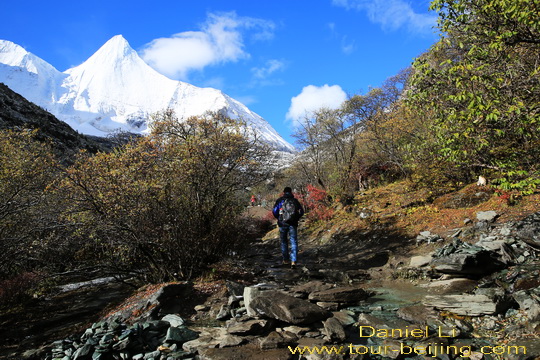
Walking on the beaten path on the meadow slope that hikers and horses share on leading to Milk Lake and Five-Color Lake.
With the white sword Jambeyang high above our left side, we feel its power and strength giving us inner peace and calmness.
A close-up view of Jambeyang and prayer flags fluttering.
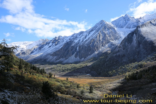
We turn around, seeing a small part of the Luorong Grassland valley down below with majestic views of alpine meadows, forested slope, rocky and snow-capped mountains, white clouds and blue sky.
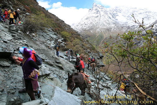
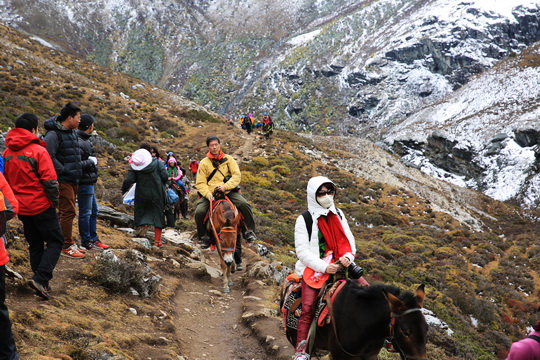
Hikers and mules use the same trail road. Some segments are just muddy with mixed dirt and poop left by mules and horse.
People have to walk on the steep and craggy slope above the road to keep from bogging down.
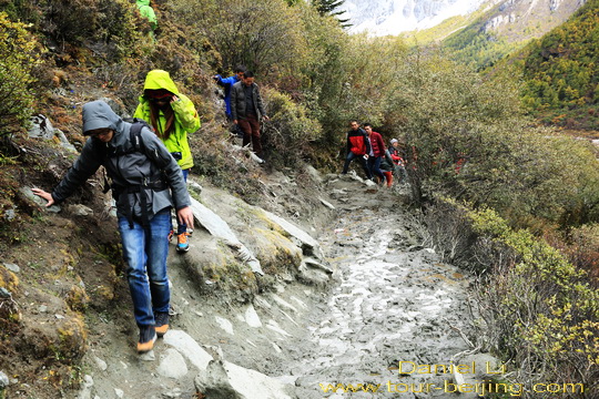
It is a continuous upward climb. The trail road becomes worse in some areas, just loose gravel and no paved path at all. We have to walk on gingerly.
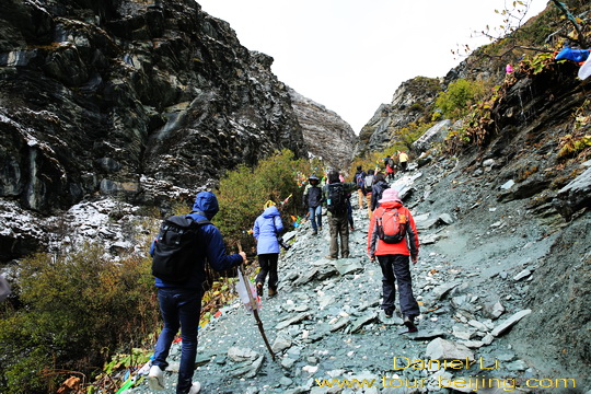
One section of the trail road (for about 200m) is not for the faint-hearted, very steep with loose scree.Very often you have to use your hands and feet to scramble up to the mountain.
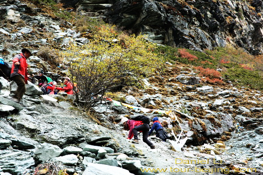
So steep and treacherous, mule riders have to get off, and mules and men climbing separately.
Be prepared with medication for emergency and high altitude sickness, regardless of whether you need it. Watch out the possible falling gravel!
The strenuous hike is rewarding with the alpine landscape. The dramatic view here reminds you of the Alps, the Rocky Mountains and Dolomites.
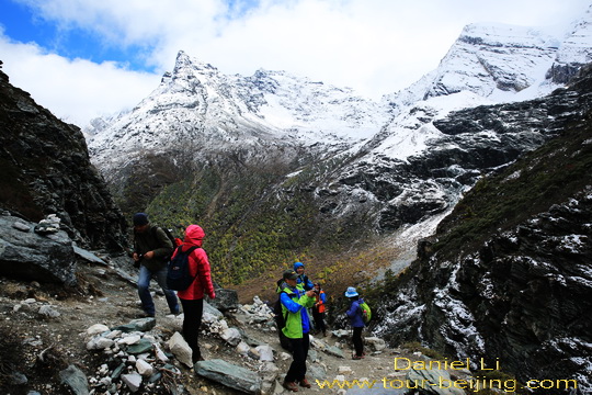
Well geared for the 6-hour hike on the above 4000m altitude – hiking pants & trail jackets; Sport sunglasses; hiking shoes; trekking poles and a light backpack.
We are now walking leisurely on the trail cutting through an open and expansive meadow slope, knowing we are approaching Milk Lake (牛奶海) at 4600m.
A group of mule riders coming up and we have to move away and let them to go.
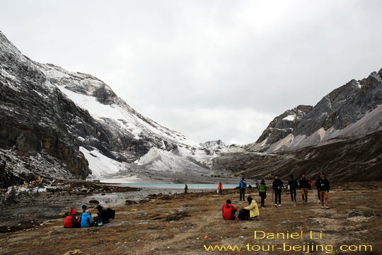
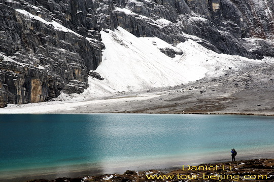
The Milk Lake at 4600m (Niunai Lake 牛奶海) is in sight. The lake is perched in the valley of Jambeyang that has a huge gap in between above the lake.
Later we find the wind comes through the gap blows the surface of the water and you cannot always see the lake with calm and mirror-like surface.
Milk Lake is dark blue with white-colored ring encircling the lake itself, hence the name of Milk Lake. It is an ancient glacier lake.
It is said that if you come here in July and August, under the sunshine you will see through the lake with multi-colored vegetation at the bottom, often billed as Seven-Colored Lake.
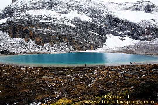
Milk Lake is set in an environment with the bleak rocky mountain side, the high mountain scree, the golden meadow and the snow. It looks cool and imposing.
On the windy open meadow surrounding Milk Lake, we randomly choose a place and sit down to grab a lunch. We bring with us biscuits, chocolates, mineral water, sliced dry beef and apples.
We decide to give up the ascent to Five-Colored Lake which takes another one hour return hike. We need to hike down the mountain to Luorong Grassland before it is too late and anyhow getting to Luorong Pasture earlier gives us more opportunity to see the grassland at its best. You know, the weather on alpine mountain areas are just changeable.
Hike back to Luorong Pasture at 4180m (洛绒牛场)
Our descent looks much easier than our previous ascent, with somewhat hiking experience on this particular trail road. The return hike takes us about 2 hours, one hour less than our hike up.
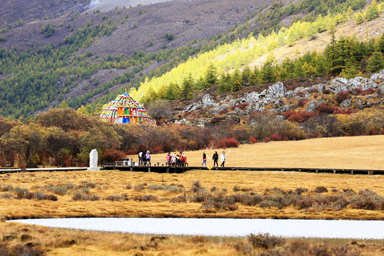
Getting down near Luorong Grassland, we feel lucky that the weather looks not bad with a little piece of blue sky. Luorong Grassland is nestled on a high and flat valley encircled by the three sacred mountains with expansive meadows and surrounding forests.
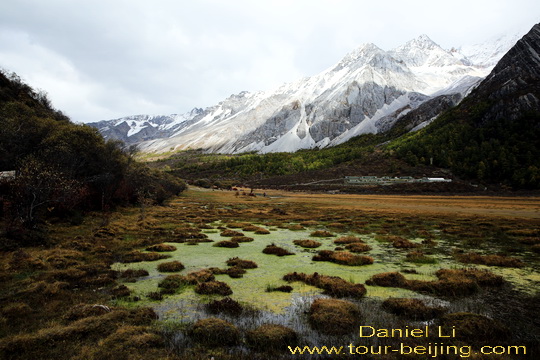
The pasture is dotted with brooks, lakes and the Gongga River cuts through the grassland posting a majestic view.
Fluffy golden meadows and multi-colored forested hillsides.
You may see a spatial structure of vegetation on the alpine mountain area here – meadows, coniferous forests and treeline and scree.
Electric Cart Ride Back from Luorang Pasture to Chonggu Si Entrance (冲古寺大门)
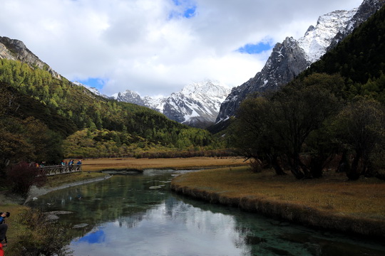
After enjoying the views of Luorong Grassland, we line up at the electric cart station going down back to the entrance near Chonggu Temple. We are going to walk 1.5 km from Chonggu Temple to Pearl Lake. Pear Lake is the best spot to see Mt.Chenrezig and its inverted reflection on the water.
While sitting on the electric cart moving down along the track, on our left side we see people walking down from Luorong Grassland on the boardwalk paralleling our cart track. The 6.7km walk from Luorong Pasture back to the entrance may take about 2-3 hour.
It is definitely a sightseeing stroll which allows you to slowly appreciate what you see in the wonderland of Yading. We would choose to walk down on the boardwalk if we had time.
Getting off the electric cart at the entrance, we see many people standing on the boardwalk by Gongga River and waiting for the shooting of sunset over Mt.Chenrezig (仙乃日6032m) and Mt.Chana Dorje (夏洛多吉5958m) .
We have to give up the idea of shooting the sunset and head on to Pearl Lake. It is 1.5 km walk from the entrance to Pearl Lake. On the way, we first come across Chonggu Temple.
It is an old and run-down temple with some new buildings nearby. Over the buildings by the side of the temple, we spot the beautiful Mt.Chana Dorje.
The 1.5km walk from Chongu Temple to Pearl Lake is very much tiring for we’ve already done the previous 5 hours’ hike from Luorong Pasture to Milk Lake.
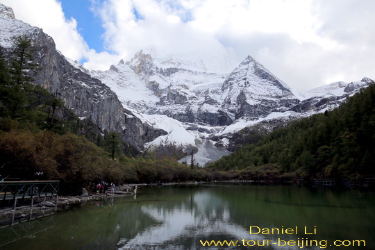
The trail is a continuous uphill climb with no flat sections at all. But the trail road is well-maintained with paved logs and stones as well. Finally, we step on one section of a flat timber walkway leading to Pearl Lake. with a backdrop of Mt.Chenrezig (仙乃日6032m) .
Pearl Lake is not big, just like a pool fed by the snow water from Mt.Chenrezig. It looks dark blue with shimmering surface, like a huge blue jade lying at the foot of Mt.Chenrezig (仙乃日6032m). The apex of Mt.Chenrezig is shrouded in white clouds.
After a short break, we retrace to Chonggu Temple, then continue to walk to Zhaguanbeng Station (扎灌崩车站 ). We line up for the shuttle bus bringing us back to the tourist center in Shangri-la Town. It is a 1.5 -hour’s bus ride. On the way back, we have the chance to see the sunset over Mt.Chenrezig and Mt.Chana Dorje.
Getting off at the tourist center at Shangri-la Town and walking to our Highlander, we start the engine and drive back along S216 to Daocheng for overnight.
Any questions, just drop a line.
Add-on
Drive from Hanzhong to Ya’an
Ya’an Night View
Most Beautiful Sky Road in China
Moxi Old Town ( Tips, Photos & Map)
Hailuogou Glacier Camp No.04 (Tips,Photos & Map)
Hailuogou Glacier Camp No.03 (Tips, Photos & Map)
Kangding (Tips, Photos & Map)
Drive from Kangding to Xinduqiao
Drive from Xinduqiao to Danba
Jiarong Tibetan Blockhouses
Jiarong Tibetan Ancient Watchtowers
Drive from Xinduqiao to Yajiang
Drive from Yajiang to Litang
Drive from Litang to Daocheng
Drive from Litang to Batang
Drive from Batang to Mangkang
Drive from Mangkang to Deqin
Kawagarbo Viewed from Feilaisi
Drive from Deqin to Shangri-la (Zhongdian)
Ganden Sumtseling Monastery Dwells Your Soul
Pudacuo is an earthly paradise
Drive from Shangri-la to Daocheng
Drive from Daocheng to Yading
Yading Brings You Inner Peace
Hassle-free Chengdu & Sichuan Guided Tours
If you don’t want to go the do-it-yourself route and prefer the hassle-free escorted tours, here are some options for Chengdu and Sichuan guided tours:
Chengdu tour
Chengdu Car Rental with Driver
Create My Chengdu Trip
Jiuzhaigou Tour
Sichuan Tour
Further Readings
Top 10 Attractions in Chengdu
Best Time to Visit Chengdu
Chengdu Airport
Railway stations in Chengdu
Chengdu Taxi
How to visit Wuhou Shrine
How to visit Du Fu Thatched Cottage
How to visit Jinsha Site Museum
How to Visit Tomb of Wangjian
How to Visit Wangjiang Tower Park
How to Visit Qingyang Taoist Temple
How to Visit Jinli Street
How to visit Kuan Alley and Zhai Alley
How to visit Qintai Road, Qintai Street Chengdu
How to visit Shaoling Road Bar Street
How to Visit Jiuyanqiao Bar Street
The Old Teahouse in Pengzhen Town, Chengdu
Bipenggou is a fairyland in Autumn
When is the best time to visit Jiuzhaigou?
Best Places to Visit Autumn Leaves in Sichuan
Top 10 Places to Visit in Sichuan
Ruoergai Grassland, my first trip to Ruoergai Grassland
Hi, my husband and I are interested in hiking the Outer Kora trek at Yading Sichuan. However, we would like to pay for a guide. They only need to speak Mandarin Chinese as my husband speaks Chinese. We would need to start the hike around the 29th of July due to work commitments.. Can you please let us know how much a guide for this trek would cost? Thanks for your help.