")

")
")

")
Changyucheng Village is named after one of the famous military city circling an important pass of the Great Wall called “Changyucheng”, which literally means “长峪城 – Long Valley City”. Bordering Hebei Province, Changyucheng Great Wall boasts to have one of Beijing’s highest Great Wall towers at the sea-level of 1400 meters with stunning views.
The ancient Changyucheng military walled city was set up 500 years ago in Ming Dynasty to accommodate the garrison manning the pass as well the nearby sections of the Great Wall. If the soldiers stationed on the Great Wall on the high mountain spotted invaders, the main troops in the pass city would be dispatched there to man the defenses.
Changyucheng Village is located in Changping District, approxi.100km northwest of the city center of Beijing.
On Feb 13, 2011, with my co-worker, Xiao Hao, we explored the ancient village Changyucheng and hiked the Great Wall near the village despite of the snowfall,a frist stop on our 5-day Great Wall tour. We write the following travel tips for you to plan your own excursion to Changyucheng.
Beijing Downtown – Changyucheng Village Driving Route
Drive along Jingzuang Highway G6, the same highway to Changping District, Juyongguan Great Wall and Badaling Great Wall . We got off at Chenzhuang (Nankou) Exit 36 which is between the center of Changping District and Juyongguan Great Wall.
So, getting off Jingzuang Highway at Chenzhuang (Nankou) Exit 36 陈庄(南口)36出口, follow your nose north, then turn left at the Chenzhuang Bridge (陈庄桥). Crossing under the bridge, then immediately turn right (north) and drive along the provincial road till you come across a fork – Dongdajie Lukou of Nankou Town (南口镇东大街路口), then you turn left (southwest ) on Nanyan Road(南雁路).
Continue to drive along Nanyan Road (南雁路), passing Liucun Town (流村镇), Mapaoquan Village (马刨泉村), then turn north and get to Changyucheng Village (长峪城村)

The village has a long history dating back to the Ming Dynasty 500 years ago. Its former military pass town was one of three most famous border passes of the Great Wall around Beijing with ancient military importance.
The ancient city wall in front of the village, embrasures and the defense inner town are still visible. The old gate is still there. On the west of the village and on the high platform, there is the Yongxing Temple with a history of over hundreds of years. In addition to Yongxing Temple. If you are lucky, you can enjoy local farmers singing and dancing.


The hiking trail from the village to the round Stone Mound on the top of the mountain
1. At the foot of the Mountain
Walking north from Changyucheng Village for 1.5km, and reach the foot of the mountain, where we start to climb up.
2. Little reservoir
Hiking up, not far, in the middle of the hill, you will see a small reservoir. The reservoir is as large as a school playground with its headwater coming from the mountain. So the view here is stunning with water passing through the forest. Some travelers just stop here BBQ, picnic and fishing. But at the time of our hiking, the reservoir is frozen with different views from other seasons.
3. A small forest

4. Jungle Corridor
Walking further up, you will pass under the “Jungle Corridor”. It is an informal name given to the road northeast of the boundary stone table.
It is a passage through the forest with trees high up and dirt road on our feet as if you are walking in an enclosed corridor, hence “Jungle Corridor”. The mountain atmosphere here is quite strong with good environment.
 on our feet as if you are walking in an enclosed corridor, hence - Jungle Corridor -.")
5. Stone Step Road
From the Jungle Corridor, you walk up along the stone step road paved by the local villagers. With you hiking higher up, the trees over your head are disappeared. Then you reach the meadow.
Before you reach the meadow, you have the most difficulty part of the hike, the most energy consuming. Most travelers will be feel dog-tired and panting.

 open and flat, a good place to take a break and fresh up")

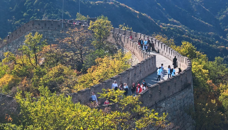
From the meadow or the big platform, you can see a round stone Mound on the mountain top. Hiking from the stone table up to the high stone mound, you can see the Great Wall snaking on the mountain range.
The watch tower is said to be the highest elevation of the watch towers in Beijing. The second tower is round, which is one of the five round watch towers in Beijing.


So if you are still energetic, you may walk extra half hour and reach the watch tower on your right side, locally known as “high-rise.” with the altitude about 1,400 meters. The Great Wall here extends in a shape of “V”, to the northeast leading to Badaling Great Wall and northwest to Hebei Province.
In the northwest of the Great Wall, for the second watch tower with a round base, is said to be one of the five circular watch towers in Beijing, locally called “the Round Building”.
If good visibility, you can have have a panorama view of the Quanting reservoir in daytime and overlook the colorfully lit city of Beijing in the evening.


The whole hiking takes approx. 4 hours, extra hour needed if you walk to the highest watch tower, locally known as “high-rise tower”.
10. Emergency Call
If you have any trouble during the hiking, please jot down the emergency phone number we find on our way up to the mountain below:

Emergency Call during Changyucheng hiking
Tip: Hassle-free Great Wall Guided Tours
Don’t want to go the do-it-yourself route? No worries, We at Tour Beijing have some options for guided tours to Great wall Tours:
Mutianyu Great Wall Group Day Tour
Mutianyu Great Wall Half Day Private Tour
Hike from Jiankou to Mutianyu Great Wall Tour
Hike from Gubeikou to Jinshanling Great Wall Tour
Hike from Jinshanling to Simatai Great Wall West Tour
Badaling Great Wall + Mutianyu Great Wall Day Tour
Badaling Great Wall and Underground Palace Day Tour
Badaling Great Wall + Forbidden City + Tiananmen Square Day Tour
Add on
Yanhecheng Village
Shuangshitou Village
Cuandixia Village
Mentougou Vernacular Dwellings Day Trip
Further Readings
Top 10 Attractions in Beijing
How to Visit Forbidden City
How to Visit Temple of Heaven
How to Visit Summer Palace
How to Visit Ming Tombs
How to Visit the Great Wall of China
How to Visit Tiananmen Square
How to Visit Hutongs
How to Visit Olympic Sites
Top 10 Markets in Beijing
Top 10 Shopping Malls in Beijing
Beijing Shopping
Wangfujing Night Snack Street
Qianmen Commercial Street
Beijing Huguosi Street